
Hiking Lenght: 4.1 miles
Elevation Gain: 700 feet
Hiking Time: 2 hours
I’d known for a while that the Shaw Butte Trail is one of the most popular trails in Phoenix, AZ, because it provides decent mountain views without traveling very far from the city.
So, of course, I added it to my list and set out to experience this “mountain trail in the city” myself.
From Phoenix, you can easily see the Shaw Butte mountain in the north Valley Skyline, which probably explains why it is so popular with both locals and tourists.
It tempts you from down below and makes you wonder what the view is like from the top.
I’d also heard about the great desert ecosystem in the North Mountain Preserve and knew I’d want to visit more than one North Mountain hiking trail during my visit.
I figured that the Shaw Butte hike was an excellent place to start.
Read on to find out everything you need to know about hiking the Shaw Butte Trail in Phoenix, Arizona.
Where is Shaw Butte Hiking Trail?
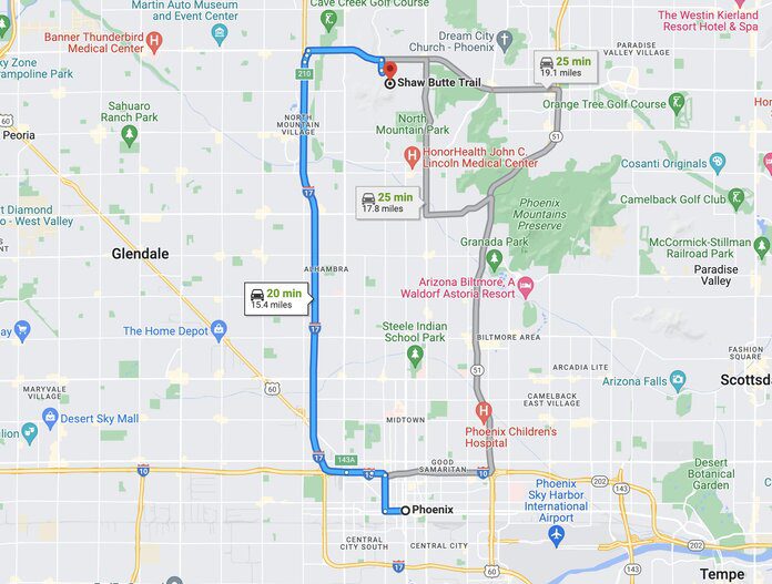
You will find the Shaw Butte trail in the North Mountain Preserve in Phoenix, AZ.
Get there by car by driving to the North Mountain Visitor Center at 12950 North 7th Street, Phoenix, AZ.
You can also take the Valley Metro Transit system to the preserve. Various bus routes throughout the city can take you to the Visitors Center.
Tickets cost $4.00 daily for adults and $2.00 for seniors and children 6-18. Children 5 and under ride free.
Do You Need a Permit for Shaw Butte Trail?
No, you do not need a permit to park or hike the Shaw Butte Trail. Parking areas in the North Mountain preserve are free and are open from 5:00 AM to 7:00 PM daily (9:00 PM in summer) and allow you to hike any North Mountain trail.
Shaw Butte Trailhead
We accessed the Shaw Butte trailhead from the left of the visitor center of North Mountain Preserve.
At the visitor center, you can find trail maps and learn more about the preserve.
You’ll also find a gift shop that sells snacks/water, gifts, local artist crafts, restrooms, and a water fountain.
Trail Description
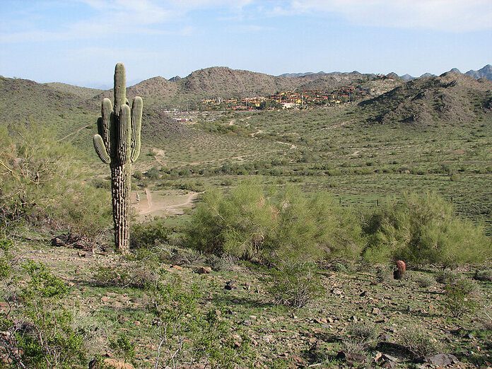
Immediately upon starting the trail, I no longer felt like I was in the middle of the city and could see why it was one of the best spots for hiking around Phoenix.
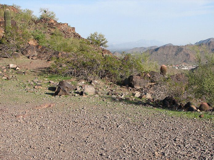
The terrain is very unspoiled and natural, which was a pleasant surprise.
I always enjoy making a loop trail and was excited that this one would loop me the 4.1 miles from the start back to the parking lot without having to turn back.
I decided to hike in a counter-clockwise direction, but many others were starting in the opposite direction.
Several other visitors had their dogs with them. Dogs are allowed on this trail but must remain on a leash.
I saw a few families with children as well, so it seemed like a family-friendly hike. Also, note that no camping is allowed in the preserve, and there are not very many campgrounds close by either.
Right away, I noticed the trail was a bit rocky, although not terribly steep, I was glad I had on sturdy shoes with good tread.
The trail is clearly marked, although a few areas have some markers missing, and if you aren’t paying attention, you might take a wrong turn. If you have your map from the visitor center, you should be OK.
Along the way, I saw various desert vegetation and wildflowers and stopped at each of the several rest areas to hydrate and take in the views. I’ve heard some hikers see falcons, but I didn’t catch a view of one on my hike.
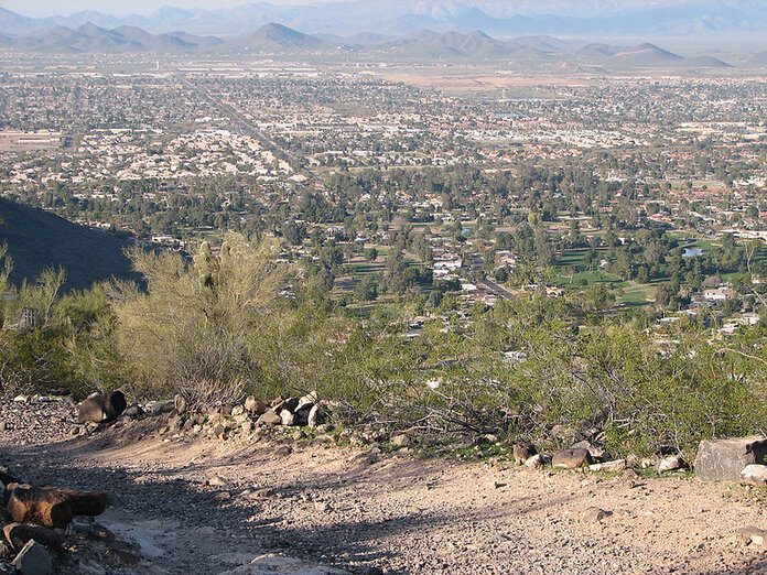
Of course, the views only got more impressive the higher up I walked. By the time I reached the top, I had completed three switchbacks, which were not overly difficult. The elevation gain was about 700 feet.
At the top, I saw 360-degree views of Downtown Phoenix, Lookout Mountain, and North Mountain. Many other hikers were also checking out the views. I did this hike in the morning, but I imagine it would be beautiful during sunset.
After taking in the views, I continued down the trail. I passed by the remains of the old “Cloud Nine” restaurant. In the 1960s, this was an elite Phoenix restaurant. It burned down to the ground, and the owners never rebuilt it.
Now, hikers stop at the old concrete foundation to get some beautiful views of the valley.
The rest of the way back to the parking lot was not strenuous, and back at the visitors center, I could rest and rehydrate.
Other hikes nearby:
Best Time to Hike It
The trail is open year-round, but the best time to hike it is between October and April. The summer months can be excruciatingly hot, especially in the middle of the day. If hiking in the summer, plan an early morning hike.
Tips and Recommendations
After completing the hike, here are my recommendations for hiking Shaw Butte.
- If you bring your dog with you on the hike, please clean up after it. I saw many indications that hikers did not adequately do that.
- As with any hike in Phoenix, bring lots of water. A reusable water bottle should work fine, and you can refill it from the drinking fountains at the end of your hike.
- It’s really cool to see Phoenix and the surrounding area from the top. If you think to pack a pair of travel binoculars with you, you can spend some time signaling out specific city landmarks. Here are a few pairs that my team and I tried out and recommend.
- If you don’t want to start from the Visitors Center, you can also join the Shaw Butte Trail through trail 306. That trail starts on a wide service road currently only used for emergency vehicles.
FAQs
The Shaw Butte elevation is 2149 feet total. Your elevation gain during the hike is just about 700 feet.
The Shaw Butte trail is a loop trail that is 4.1 miles total from start to finish. It should take the average hiker about 2 hours to complete.


